Ireland Adventure Travel Map 3303
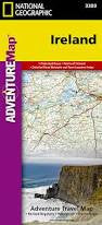
Ireland includes the locations of thousands of major cities and towns with an index for easily locating them, plus a clearly marked road network complete with distances and designations for major highways, limited access highways and more. The north side of the Ireland map details from the northernmost tip of the island at Malin Head south to Dublin and Galway, including Belfast, Dundalk, Londonderry, and Sligo. The south side overlaps the northern side of the map at Galway on the west and Dublin on east, covering the remainder of the country including the cities of Limerick, Tralee, Cork, and Waterford. An inset map provides detail of the Skellig Islands. Sites of interest from prehistoric monuments and castles to churches and abbeys are noted making this map indispensable for the traveler seeking to explore Ireland’s rich history. Popular places included on the map: Connemara Countryside, Cliffs of Moher, The Burren, Blarney Castle and the Blarney Stone, Lakes of Killarney, Giant’s Causeway, Hill of Tara, and Trim Castle. Approximately 4 1/4" x 9 1/4" folded 26" x 38" fully opened Scale = 1:385,000 (1"=6 miles) Contour Interval = 50 meters © 2019